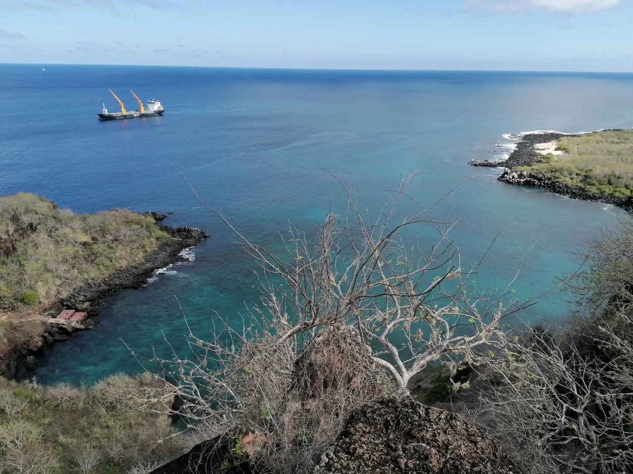
As the route rises, views may open towards the town, coast, and marine horizon, while frigatebirds recall the hill’s local name through their forked tails. The experience invites walking and observation, with any approach to the water considered only when actual conditions, signage, and available guidance allow it—without promises of views, wildlife, services, or permanent access.
A hill that begins in town and ends at the horizon
Cerro Tijeretas does not begin on an isolated summit. It begins on foot, while Puerto Baquerizo Moreno is still close and the urban edge starts to yield to San Cristóbal’s volcanic coast. The walk can lead towards the Interpretation Centre and continue along a coastal land circuit that does not divide town, landscape, and sea. It joins them gradually.
At first, the walk retains signs of nearby life. Then it gathers silence, rock, sun, and wind. The transition is not a door closing behind the walker. It appears in details: a slope that changes the rhythm of breathing, a stretch of lava that asks the eyes to follow the ground, a cactus drawn against the sky, or the sound of water returning through an opening.
Essential information
- Location
- San Cristóbal, near Puerto Baquerizo Moreno
- Access
- Can be approached on foot from town
- Landscape
- Rock or lava, cacti, and arid-zone and transition vegetation
- Name
- Associated with frigatebirds, known locally as tijeretas
- Views
- Town, coast, and marine horizon according to visibility and conditions
- Water
- Tijeretas cove or pier
The Interpretation Centre as a threshold
The Interpretation Centre works as a threshold within the route: a place where Galápagos’ natural and human history can add context before the path becomes more physical. It need not be turned into a compulsory stop, nor assigned fixed opening hours, services, or conditions to be understood as a territorial landmark. Its presence recalls that the landscape is more than a view: it is also a fabric of conservation, memory, and collective decisions.
From this setting, the walk lets the eye change scale. The town no longer fills the entire frame; the coast opens in fragments, and the slope asks for a slower reading. A built stretch may alternate with stairs and surfaces where stone requires attention. There is no single way to move through it and no correct speed. Sun, wind, humidity, signage, or closures all take part in how the day’s route unfolds.
Rock, lava, and cacti: reading the ground before looking outward
The ascent is not measured by one fixed number, but by the small decisions it asks for. A stairway may bring a change of angle; an uneven surface may call for shorter steps; an open stretch may expose the body to sun and wind. Cerro Tijeretas rewards that close attention because its geology is not only beyond the scene. It forms the ground, defines the edges, and shapes the vegetation travelling alongside the climb.
Cacti, shrubs, and plants adapted to dryness may appear along arid-zone sections. Higher up or in transition areas, vegetation can take on a different density and colour; Scalesia may be part of that change without its presence needing to be guaranteed at any particular point. The shift between environments is not an exact line drawn across the hill, but a sequence of exposure, brief shade, and life responding to relief.
Remaining on authorised paths protects that mosaic. Leaving the route for a photograph, shortcut, or shade can damage unobtrusive plants, make traces that others repeat, or approach areas that need quiet. Rock, lava, and vegetation are not souvenirs to take away; they remain part of the place when nobody moves them.
Viewpoints that do not promise the same scene twice
In higher sections, the horizon may begin to organise what has been walked. Puerto Baquerizo Moreno appears as a pattern between land and sea; the coast traces curves, coves, and shifts in colour; farther out, the ocean holds references visible only when light and clarity allow. Isla Lobos, León Dormido, or Kicker Rock may emerge from some points, but no distant name replaces the experience of looking first at what the day genuinely reveals.
The viewpoints are not boxes to tick. They are pauses for noticing how town and protected surroundings meet, how rock carries the coastal edge, and how the sea changes the reading of the island. A cloud, garúa, gleam on water, or wind can alter the scene without diminishing it. A view does not need to be complete to matter.
Frigatebirds above the sea’s edge
The name Tijeretas is associated with frigatebirds, known locally by their forked tails. When one crosses the air above the coast, its silhouette can seem to draw a dark line opening and closing against the sky. That image helps explain why the name remains connected to the place, but it does not turn flight into an assured appearance.
Blue-footed boobies or other seabirds may also appear, while finches, lava lizards, and other discreet species can pass unnoticed along the paths. Responsible observation does not try to complete a list. It means slowing down, keeping distance, and accepting that wildlife decides when to pass, rest, remain hidden, or stay out of view.
Animals are never fed, touched, or pursued. Nor are their routes between rock, path, water, and resting space blocked. A photograph has value only when it preserves that separation: available distance guides the image, and the image never redefines responsible distance.
A monument, a cannon, and the care of interpretation
The circuit may include a statue or monument dedicated to Charles Darwin and a historic cannon. The statue honours a historical relationship between Darwin, San Cristóbal, and Galápagos; the cannon adds another layer of memory to the route. Both invite careful interpretation, without making the landscape tell details that have not been confirmed.
The hill need not be presented as an exact biographical coordinate, nor the cannon as proof of a complete military story. The most honest reading recognises the objects, their presence, and their evocative role within the circuit. Looking with care also preserves the distinction between a visible landmark and a documented claim.
Tijeretas cove: approaching water without demanding an answer
The route can descend or draw closer to Tijeretas cove or pier, where rock and natural or built steps connect the coast with water. Arrival changes scale again. What looked like a blue band from above becomes a moving surface, an entry edge, and a direct reading of swell, current, visibility, and available signs.
Snorkelling may be considered only when the day allows it. Before entering, observe how the water moves, identify a reasonable entry and exit, note signage, and follow authorised or local guidance that is available. A cove that appears enclosed from the rocks does not guarantee calm, an even seabed, permanent access, or an appropriate margin for every person.
Sea lions, marine iguanas, fish, sea turtles, or rays may appear in or beside the water; none is guaranteed. Scuba diving, kayaking, and paddleboarding are not included as routine activities. When conditions are unsuitable, remaining on land and observing the meeting of water, stone, and coast is still a complete experience.
Walking does not mean the same route for every person
Cerro Tijeretas should not be described as an identical walk for everyone. Slopes, stairs, irregular rock, heat, sun exposure, wind, path condition, and signage change effort and the decisions needed. A stretch one person walks calmly may require another to slow down, pause, or turn back.
Grip-ready footwear, water, a hat, clothing suited to sun and wind, and sun protection compatible with ecosystems are part of general preparation. Snorkelling equipment is relevant only when the activity is genuinely being considered and conditions allow it. Shops, toilets, continuous shade, lighting, or other services should not be relied upon: infrastructure can change and should be checked before arrival.
Two periods, many decisions made on the day
From approximately December to May, the setting is generally warmer and wetter. Heat, rain, insects, light, and the look of vegetation can all change the walk. From approximately June to November, conditions are generally cooler and drier, with possible wind or garúa and a coastline that may offer another reading of the sea.
These are tendencies, not promises of weather, water, views, or wildlife, nor an answer to which time is best. Every outing meets a different combination of light, path, sea, and wild activity. Arriving ready to adapt the plan matters more than pursuing a scene fixed by the calendar.
Simple rules for a living circuit
National Park rules, current signage, and closures take priority over every expectation of continuing along a section or reaching a particular point. Plants, rock, lava, and other natural elements are not collected; every piece of waste leaves with the person who brought it. Keeping paths and the coastal edge free of new traces helps the circuit remain both refuge and landscape.
Wildlife needs distance, clear routes, and relative quiet. It is not touched, fed, or pursued, and drones are not used unless current rules and applicable authorisation permit them. Before taking one, current regulations must be checked and respected; an exception or a universal prohibition should never be assumed out of context.
Frequently asked questions
- It can be approached on foot from town as part of a coastal circuit connected with the Interpretation Centre, Punta Carola, and Tijeretas cove. No duration is set because route and conditions vary.
- The name is associated with frigatebirds, known locally as tijeretas because of the forked shape of their tails. No unverified etymology is added.
- No. Slopes, stairs, irregular rock, heat, wind, signage, and closures change demands and the possible route.
- That should not be assumed. The circuit can combine built stretches, stairs, and natural or uneven surfaces.
- No. Frigatebirds, blue-footed boobies, and other seabirds may appear, but wildlife is wild and never guaranteed.
- Depending on visibility and conditions, views may open towards Puerto Baquerizo Moreno, the coast, Isla Lobos, León Dormido/Kicker Rock, or other horizon features. No view is promised.
- They are interpretive landmarks within the circuit. The statue honours Darwin’s historical relationship with San Cristóbal and Galápagos; the cannon is a historic feature described without unverified details.
- It may be considered only if swell, entry and exit, current, visibility, signage, and available guidance provide an appropriate margin. The cove is not presented as always calm or accessible.
- Sea lions, marine iguanas, fish, sea turtles, or rays may appear, but no species or encounter is guaranteed.
- No. The available factual basis does not support presenting them as routine activities at the site.
- Grip-ready footwear, water, a hat, ecosystem-compatible sun protection, and clothing suited to sun and wind. Snorkelling equipment is relevant only when the day and activity allow it.
- Shops, toilets, shade, lighting, and other services should not be assumed. Infrastructure can change, so current conditions should be checked.
- Review and respect current regulations and any applicable authorisation before using one; no exception should be assumed.
The return: when coast becomes town again
On the way back, the circuit does not repeat itself. The slope is read from another angle, cacti change their outlines, and the sea appears through gaps that were once behind the eye. Town returns gradually, not as an interruption of the landscape, but as one of its layers: the place where the walk began and to which the experience returns.
Cerro Tijeretas leaves a memory made of transitions. Port and coast, rock and vegetation, stairway and horizon, frigatebird and quiet, sea surface and the edge of the cove. Its value does not depend on completing it or obtaining a particular view or encounter. It comes from walking attentively through a territory that changes while it is being observed.