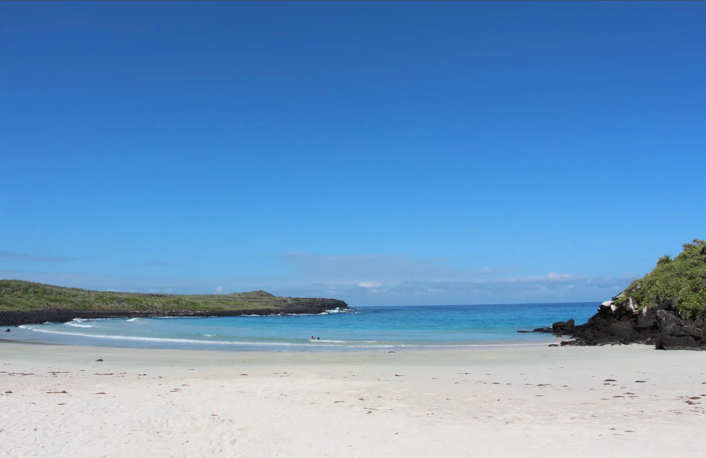
A short path passes through arid-zone vegetation before revealing a beach framed by dark volcanic rock, where the water may take on turquoise tones as light and conditions change. Contemplation, walking, photography, and responsible observation share the setting with in-water activities that should only be considered after reading the actual sea that day, without promises of calm, access, or wildlife.
One road through several islands within an island
Puerto Chino begins long before the sea comes into view. The overland journey leaves the surroundings of Puerto Baquerizo Moreno and crosses into San Cristóbal, passing through El Progreso and the highlands before descending towards the road’s end. Over approximately 24 kilometres by road, landscape, humidity, colour, and texture shift as though one island held several worlds joined together.
The transition does not happen like a curtain lifted all at once. The urban setting recedes, the relief leads inland, and vegetation responds to changing height and exposure. Farther on, the horizon opens again and the terrain takes on drier, coastal features. Reading those changes turns the journey into the first chapter of discovery rather than an interval to be measured by a fixed time.
No exact journey duration is given because pace depends on the starting point, weather, traffic, and road conditions. The approximate distance helps locate the place; a clock can create certainty that the real crossing does not offer. Responsible arrival begins by understanding the difference between orientation and promise.
Essential information
- Location
- San Cristóbal, at the end of the road from Puerto Baquerizo Moreno
- Distance
- Approximately 24 km by road
- Final approach
- A short path commonly described as taking 10–15 minutes
- Landscape
- Fine white-sand cove, dark volcanic rock, and arid coastal vegetation
- Activities
- Contemplation, rest, walking, wildlife, photography, swimming, and uses of the sea
- Services
- Very limited and subject to change
- Wildlife
- Wild and possible
From highland moisture to arid-zone light
Crossing San Cristóbal reveals a transformation that a map can easily hide. The highlands may hold cooler air, moisture, or low cloud, while the descent gradually restores the strength of the sun and the colours of dry vegetation. These are not fixed borders: season, hour, and daily weather alter every transition.
As the road nears Puerto Chino, open spaces and arid-zone vegetation invite a different kind of attention. Cacti, shrubs, twisting branches, and plants adapted to scarce water can look spare from a distance, then reveal detail when viewed without hurry. The coast is not fully visible yet; it announces itself through light, wind, and the widening sky.
That change of environment shows that the beach is not separate from the rest of the island. Sand, rocks, path, and vegetation form an ecological sequence. Crossing it carefully allows the destination to become more than a strip beside the water: it becomes a reading of the territory.
The path that keeps the cove hidden
From the end of the road or access area, a short path begins, commonly described as a walk of about 10 to 15 minutes. That is guidance, not a guarantee. Pace, heat, terrain, and the need to pause can change both duration and perceived difficulty, so the path should never be presented as identical for every person.
The route crosses coastal and arid-zone vegetation. In places, branches, shrubs, and patches of shade may draw together over the way, creating the feeling of a small green tunnel. This is not dense forest or a promise of continuous shade, but a changing sequence of clearings, dry textures, and brief shelters where the eye learns to search for life at a smaller scale.
Finches, mockingbirds, or lava lizards may appear among soil, branches, and stones, or they may remain out of sight. Moving slowly supports observation without pursuit or departure from the trail. Silence does not mean absence; sometimes discovery lies in a mark, movement between leaves, or a call whose source remains concealed.
The path deserves the same attention as the beach. Leaving it can damage sensitive vegetation, approach resting or nesting areas, and establish traces that others may follow. Remaining on the authorised route protects the place and also reduces exposure to irregular rock, thorns, and unstable ground.
Small plants holding an entire landscape together
Arid-zone flora does not need height to matter. Among cacti, shrubs, and coastal vegetation, sensitive endemic plants such as *Calandrinia galapagosa* and *Lecocarpus darwinii* may occur. Naming them neither guarantees their presence nor assigns an exact legal or threat category here; it recalls that even the least conspicuous vegetation belongs to a singular island system.
These plants must not be touched, pulled, or collected. Nor should anyone leave the path for a closer photograph. One step beyond the trail can affect a specimen that is difficult to recognise or compact the soil supporting it. In this case, distance does not diminish discovery; it allows something to be seen without becoming a possession.
Vegetation that withstands sun and dryness is not invulnerable. Observing shapes, seeds, flowers, or colour contrasts from the trail reveals how life adapts without requiring it to be handled. Care begins by recognising that small forms also organise the landscape.
The reveal of sand and sea
The cove does not give itself away at once. After the close-held path, light grows, space widens, and a band of fine white sand appears between outcrops of dark volcanic rock. The contrast can feel like a natural doorway opening onto the ocean, although the place needs no legend to make it extraordinary.
The water may show turquoise tones when light, sky, depth, and the state of the surface align. At another moment it may look darker, clouded, or rougher. Describing that variation preserves the real wonder: colour is not fixed paint but a shifting response between sea and day.
Pale sand softens the outline of the cove, while rocks at either end recall the volcanic origin of San Cristóbal. Between them lies a landscape of edges: dry and marine, bright and dark, open and only apparently sheltered. That combination explains why Puerto Chino may feel intimate while remaining exposed to the ocean’s movement.
The first pause can simply be used to watch. Following the line of breaking waves, noticing the way water moves, and locating available signs provide information before any activity is chosen. Reaching a beach creates no obligation to enter the sea; contemplation is already a complete experience.
A name drawn by an outline
A popular explanation links the name Puerto Chino with a nearby hill or promontory whose outline may recall a Chinese hat. It should be understood as a traditional or probable reading of the landscape, not a proven etymology. The resemblance depends on angle, distance, and the imagination brought to the view.
The explanation fits the way the place is discovered: first as a contour, then as a gathering of details. The promontory need not become a character or receive an invented story. It is enough to follow the line of rock and recognise how a familiar figure can emerge in natural relief.
Sand for pausing, not taking
The beach makes room for rest, observation, and photography attentive to the landscape’s forms. Natural shade may be limited and shift throughout the day, so it should not be relied upon. Drinking water, a hat, and sun protection compatible with marine ecosystems are part of reasonable preparation without becoming promises of comfort.
Toilets, drinking water, food, or other services should not be assumed at Puerto Chino. Infrastructure can change, and current conditions should be confirmed before arrival. Being prepared reduces pressure to improvise and makes it easier to remove every piece of waste, including small items that wind can carry towards vegetation or sea.
Sand, stones, plants, and every natural fragment remain at the site. Taking one sample may seem minor, but repetition changes a place. Memory can hold colour and texture without removing any part of the landscape.
Reading the sea before entering
Puerto Chino should not be reduced to one word such as calm or safe. Swell, current, breaking waves, and visibility change from day to day and may alter during a single stay. Before entering, watch the surface, pay attention to signs, and follow authorised or local guidance that is available.
A cove can look sheltered from the sand while concentrating water movement near its edges or breaking zone. Pale colour alone reveals neither depth, current, nor seabed. A responsible decision rests on actual conditions and personal ability, not on an earlier photograph of the place.
If the sea changes, the plan should change with it. Remaining out of the water, shortening an activity, or choosing contemplation does not diminish the visit. Adaptation preserves discovery and avoids turning expectation into obligation.
Swimming without turning the cove into a promise
Swimming may be considered when conditions, signs, and personal assessment allow. It is neither guaranteed nor uniformly simple. Breaking waves, current, temperature, and each person’s experience alter the available margin.
Entering gradually can help reveal the movement of the water, but it does not replace appropriate assessment. Keeping the exit in view, avoiding areas beyond personal ability, and responding to change matter more than reaching a particular part of the cove.
If sea lions or other wildlife are present on the shore or in the water, their space comes first. They must not be touched, fed, pursued, or surrounded, and their route between sea, sand, and rock must never be blocked. A responsible encounter may mean stepping back and letting the animal choose its way.
Snorkelling beside rock, only when the day allows
Snorkelling is often imagined near the rocky edges, where relief may offer another reading of the cove. That possibility depends on swell, current, breaking waves, visibility, and local guidance forming an appropriate whole. Proximity to rock requires a greater margin, not automatic confidence.
Green sea turtles, rays, or fish may appear in the water, but none is guaranteed. Visibility can change, and an outline may vanish before it can be recognised. Watching without pursuit preserves both personal safety and the freedom of wildlife.
A mask and other equipment should be fitted before entering, and no image justifies approaching rock in breaking water, moving away from responsible guidance, or exceeding personal limits. When conditions are unsuitable, the surface landscape still offers a complete experience.
Surf and the energy of breaking water
The same site sometimes described for its peaceful appearance can receive enough swell for surfing. That apparent contradiction is a reminder that the sea is variable. Surfing requires suitable experience, an understanding of the break, and assessment of the day’s conditions; it should not be promoted as a universal option for beginners.
The shape of the cove, seabed, swell direction, and currents can alter the demands. No season, level, or ideal condition is fixed here. Entering depends on current information and an honest assessment of personal ability.
Those not surfing can observe the water from a safe position outside lines of movement. Sharing the beach means not crossing trajectories, approaching wildlife for an image, or treating another person’s activity as proof that the sea suits everyone.
Wildlife choosing when to appear
Galápagos sea lions may rest on the sand, occupy a rock, or move through the water. Their presence must never be interpreted as an invitation to contact. Keeping distance, leaving their path clear, and moving elsewhere when necessary allow the beach to remain habitat rather than a stage for interaction.
Green sea turtles and rays may appear in the water. Blue-footed boobies, Nazca boobies, frigatebirds, pelicans, and other seabirds may also be observed from shore or rock. No species, number, proximity, or behaviour is guaranteed, and the visible absence of animals does not make the landscape empty.
Finches, mockingbirds, and lava lizards may occur along the path and among vegetation. Their movements are often brief and need not be provoked. Avoiding calls, food, pursuit, and approaches beyond the trail keeps observation within the bounds of wild behaviour.
Resting and nesting areas demand particular care. Closed or unauthorised sectors must not be entered, passage must not be forced between animals, and proximity should never be used to manufacture a photograph. The best observation accepts that wildlife may move away, remain hidden, or not appear.
The promontory and the cove from above
A short ascent or route over the promontory and rocks may offer views of the cove and coast where an authorised trail exists and conditions allow. From above, the sand takes on a clearer shape, rocks define its edges, and water reveals changes in tone and movement.
The elevated perspective removes none of the precautions. Sun can be intense, rock irregular, and wildlife may use areas that should not be entered. Following only permitted routes, respecting closures and signs, and avoiding exposed edges keeps contemplation within a responsible framework.
The viewpoint is not compulsory. If terrain, heat, trail conditions, or local direction advise against continuing, the beach retains its value from below. Discovery does not mean occupying every available point; it includes understanding when to stop.
Photographing light, rock, and distance
Puerto Chino offers contrasts that change quickly: pale sand, dark rock, brief shadows, dry vegetation, and water responding to the sky. Photography and filming can follow that transformation without requiring a prepared scene. A broad composition may tell as much as a close view.
Equipment should remain secured and outside the path of people and animals. Plants, stones, or natural features are not moved to arrange an image, and closed or nesting areas are never entered. Available distance defines the image; the image does not redefine responsible distance.
With wildlife, a moment may last only seconds. Accepting a distant, partial, or absent photograph avoids turning an encounter into pursuit. Memory of the landscape does not depend on proving that a species was there.
Two periods, many daily variations
From approximately December to May, conditions are generally warmer and wetter. Heat, rain, and insects may be more noticeable, but no element occurs in the same way every day. Hydration, sun protection, and clothing suited to the environment deserve flexible planning.
From approximately June to November, conditions are generally cooler and drier. Wind, garúa, or cooler water may occur. These tendencies guarantee neither cloud, calm water, nor a particular temperature.
There is no universal best time. Each period alters light, vegetation, thermal comfort, and sea conditions, while each day keeps its own combination. Repellent or suitable clothing may be considered when insects are more active, without replacing personal needs or appropriate guidance.
Arriving prepared where services are limited
Puerto Chino should be approached without assuming toilets, drinking water, food, or other services. Infrastructure can change, and its current condition should be confirmed. Carrying what is needed and removing every piece of waste protect a site where options for resolving the unexpected may be limited.
Shade may be limited on both path and beach. Water, a hat, sun protection compatible with marine ecosystems, and clothing appropriate to conditions are general preparations. Heat, exposure, and terrain should be assessed according to each person’s abilities.
If arrival by bicycle is being considered, the road crosses changes in elevation and may be demanding. It requires fitness, experience, enough water, assessment of weather and traffic, and responsible planning. It is neither a simple alternative nor a general recommendation; walking from Puerto Baquerizo Moreno is not presented as an ordinary means of access either.
Camping, if current rules allow it at all, is neither free nor spontaneous. It requires prior authorisation from the competent authority and confirmation of current regulations. Mention of the possibility is not permission to stay overnight.
Simple rules for protecting a complex cove
Keeping distance from wildlife, never touching, feeding, or pursuing it, and leaving sea-lion routes clear are rules for sand, water, trail, and rock. No universal number is needed to recognise when presence changes an animal’s rest or movement: if its behaviour changes, distance should increase.
Remaining on authorised trails prevents damage to sensitive plants and approaches to nesting areas. Sand, stones, plants, and other natural elements are not collected. Closures and signs take priority over every expectation of reaching a viewpoint or particular sector.
Every piece of waste leaves with the person who brought it, including small fragments. In wind, a light wrapper can leave the beach in seconds. Responsibility does not end when something disappears from view; it ends when it is removed from the area properly.
Frequently asked questions
- It can be described as a fine white-sand beach held within a cove, framed by dark volcanic rock and arid coastal vegetation.
- The publishable reference is approximately 24 km by road, following the route through El Progreso and the highlands. No journey time is fixed.
- It is commonly described as a short walk of about 10 to 15 minutes, but pace, heat, and trail conditions change duration and difficulty.
- That should not be claimed. There is heat exposure, natural terrain, and changing conditions; each person should assess their abilities and current information.
- A popular or probable explanation links the name with a hill or promontory whose outline recalls a Chinese hat. It is not presented as a proven etymology.
- No. Colour depends on light and conditions, while swell, current, breaking waves, and visibility change. Appearance from the sand does not guarantee safety.
- Swimming may be considered only when conditions, signs, available guidance, and personal ability provide an appropriate margin.
- It may be considered, often near rocky edges, only when swell, current, breaking waves, and visibility are appropriate. Rock requires additional caution.
- It is not presented as a universal option for beginners. Surfing requires suitable experience and an understanding of the day’s conditions.
- It is not included as a routine activity because the available factual basis does not support that claim consistently.
- Galápagos sea lions, green sea turtles, rays, boobies, frigatebirds, pelicans, finches, mockingbirds, and lava lizards may occur, among other wild animals. Nothing is guaranteed.
- A short route over the promontory or rocks may offer views where an authorised trail exists. Closures, signs, sun, irregular rock, and wildlife must be respected.
- They should not be assumed. Services are very limited and can change; current conditions should be confirmed and visitors should arrive prepared.
- Only when prior authorisation from the competent authority exists and current regulations allow it. It is not a free or spontaneous activity.
- The road crosses changes in elevation and may be demanding. It requires fitness, experience, water, and assessment of weather and traffic; it is not a general recommendation.
- There is no universal answer. December–May is generally warmer and wetter; June–November is generally cooler and drier. These are tendencies, not guarantees.
- Keep distance from wildlife, leave routes clear, remain on trails, collect no natural elements, remove waste, and respect closures and signs.
The return puts the journey together again
On leaving the sand, Puerto Chino gradually hides itself again. The cove narrows between rocks, the sea appears in fragments, and the path returns to the scale of branches, cacti, shrubs, and dry ground. The green tunnel that once announced a reveal now becomes a transition back inland.
The return allows details overlooked in the expectation of arrival to come forward: a shadow on the path, the shape of a leaf, a shift in the wind, or the distance between the last sound of breaking water and the silence of the arid zone. Going back does not repeat the path; it reads it from another direction.
The road then joins the coast once more with the highlands, El Progreso, and Puerto Baquerizo Moreno. The beach falls behind, but memory keeps the full sequence: the island crossed, the sheltered path, light opening over the sand, the variable sea, and the choice to observe without requiring the place to guarantee anything.